


Tour des Chapelles

andre06130
User
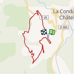

Length
4.2 km

Max alt
1595 m

Uphill gradient
258 m
Km-Effort
7.6 km

Min alt
1343 m

Downhill gradient
251 m
Boucle
Yes
Creation date :
2014-12-10 00:00:00.0
Updated on :
2014-12-10 00:00:00.0
1h43
Difficulty : Unknown

FREE GPS app for hiking
 SityTrail
IGN / Geographical institutes
SityTrail Plus
The world is yours!
About
Trail Walking of 4.2 km to be discovered at Provence-Alpes-Côte d'Azur, Alpes-de-Haute-Provence, La Condamine-Châtelard. This trail is proposed by andre06130.
Positioning
Country:
France
Region :
Provence-Alpes-Côte d'Azur
Department/Province :
Alpes-de-Haute-Provence
Municipality :
La Condamine-Châtelard
Location:
Unknown
Start:(Dec)
Start:(UTM)
320143 ; 4924768 (32T) N.
Comments